Year by Year
Discover the history of the HMS Cossack from 1854 to 1875.
You can search the ‘year’ and ‘month’ to find a specific date and also ‘click’ on the date itself to reveal any images and moments from that date.
27 March 1871
Wind variable light airs becoming SSW force 3. Barometer 30.04 inches. Maximum temperature 85F.
0515. Unmoored and weighed port anchor.
0745. Weighed and proceeded under steam with Bengal marines 8th Nemesis in company.
0800 Steamed down Rangoon River. Saluted flag of Chief commissioner with 13 gun salute and manned the yards. We weighed at top of high water and therefore had the ebb tide down.
1310 Discharged the pilot. Shaped course SW by S.
1410 Fairway buoy NE ½ N 3 miles. Set fore and aft sails.
1900 China Buchur Light bore north.
2000. Lost sight of light.
31 March 1871
Wind variable force 1 becoming west force 2.
0530. Weighed.
0540 Proceeded under steam. Exercised a General Quarters firing shot and shell at target.
0630. Proceeded up to Akyat. Found NEMISIS and Mail steamer DACCA at anchor.
0820 Came to with broken bottom in 4 ¾ fathoms and veered to two shackles. Moored off town of Akyat. River Aracan.
1410. Left Akyat under steam.
1600 Savage Island Light north. Eight point of Bolonga SE ¼ S. Under steam and fore and aft sail
Remarks ( Copied as written)
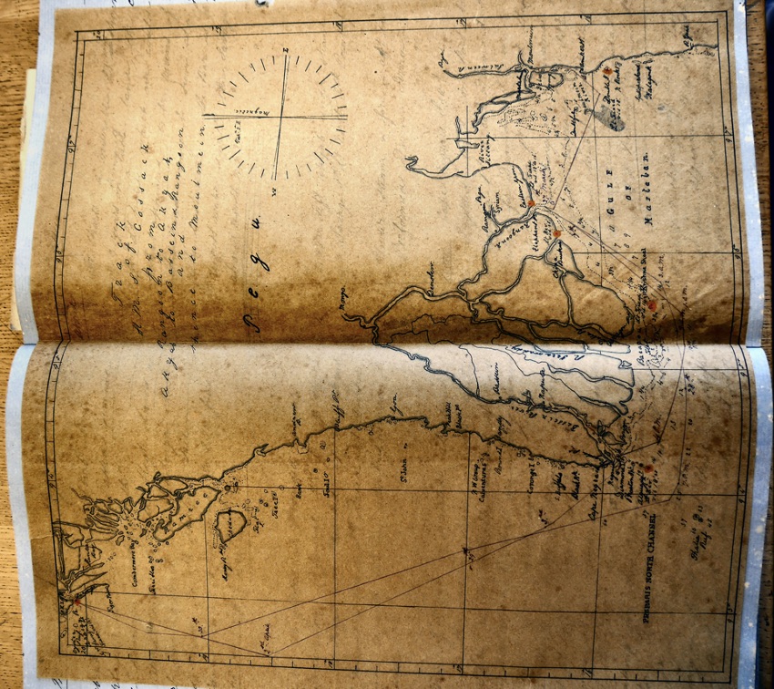
The town of Akyat is situated at about 8 miles up the Aracan River on the north bank. There is a tolerable amount of trade in rice and butternut. There are very few houses to be seen from the anchorage. On the charts a light is placed on Borongo island but it is no longer inhabited. The Savage Island light appears to be a revolving one but on the charts it is a fixed one. On making for the entrance generally steer for Tableland on an easterly course until Savage Islands Light bears about north. The buoy on the south end should of shoal is shifted further to the north than what it is on the chart. A miserable light has shown for two to three years on Summit table land. The clearance for all lighthouses which we could see with what appears to be ruins of a lighthouse. This land may be seen at a great distance. The least water on the bar is 18 feet and the deepest water is with the Savage Island light bearing about NNE
03 April 1871
Latitude 16.25N. Longitude 93.43E. Course S28E. wind south force 1 becoming north westerly force 2 with broken cloud.
Under sail and steam. Performed divine Service.
Noon. Cape Nigrais S58E 41 nautical miles.
1500.Sighted land on the port bow.
1800. Pagoda Point N80E. Diamond Isle S56E. Steered for Diamond island on a SE course until Pagoda Point bore north, then steered east making an allowance for tide.
1830 sighted Alguanda Light SSE
1945. Came to in 5 fathoms with sandy bottom and veered to 2 shackles. Anchored off Diamond Isle. Anchor bearings Pagoda Point NW by W. Diamond Island SSW ½ W.
Remarks
Vessels anchoring off Diamond island should only just open Alguada light to the east of the shore nor open it too much. Cape Nigrais may be known by the rocks off it and also being at the end of a range of high land. Pagoda Point had a pagoda on its very point and is therefore very conspicuous. Porian Point is very low with white cliffs. Received a pilot from Diamond island and started up the river on the morning of the 4th. Alguada Light on with east end of Diamond leads clear of Fairway buoy. During the SW monsoon the sea breaks very heavily on outer shoals and raises a very heavy sea. In the channel. The south buoy on the outer shore has been washed away and not replaced. Port Dalhouria although described in sailing directions does not exist.. The channel between Negrais Island and mainland is blocked up. The Fairway buoy is red and marked as Fairway bearing NE one nautical mile and a half. The town of Bassein is situated about 80 feet up high on the on the east bank. There are several villages on the way up. The largest of which is Napecta just above the junction. The passage to the north of Diamond Point island should not be attempted during the SW monsoon by sailing vessels. Diamond Point is a low island covered with trees. There is a pilot station house where the pilots board from.
06 April 1871
0400. Proceeded down river in charge of pilot at high water. Wind variable force 2 becoming WNW force 3. Found on weighing port anchor that the stock was broken off. Caused most probably by the ship over running her anchor and fouling the stock with her cable.
0800 Abreast Enterprise island. Noon sighted Diamond island SSW ½ W. made sail.
1415. Discharges pilot.
1430 Diamond island bore west. Shaped course SSE.
1615 Alguada Light House W by N ½ N. Course E by S ½ S. Squred yard.
2230 Altered course E by N.
13 April 1871
Wind light and variable becoming south westerly force 2. Barometer 30.02 inches. Under steam and sail.
0245. Altered course to East.
0340. Double Island Light E by N. altered course NE by E ½ E.. Daylight. Land ahead.
0600. Pilot came onboard..
0630. Double island Light S47E.
0900. High water at mouth of river.
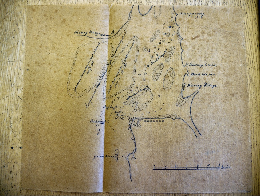
1100 Arrived of Government Pier, Maulmain. Burma (Mawlamyine, Myanmar). Came to in 7 fathoms with broken bottom and veered to 5 shackles. Let go and moored ship with 3 shackles on each cable.
Remarks
We left Fairway buoy Rangoon River at nearly high water and therefore carried on Ebb tide across the Gulf to Amherst Point and found us at 0340 13th to the south and a little off the double Island Light which was bearing E by N. It is a fixed light of great brilliance and visible for 18 nautical miles . At daybreak the high land of Armhurst island and mountains were very quickly sighted. The double island when bearing to the north of east appears as two islands. The northern part having the white light house on it..
We arrived at the Patch Buoy at ( Iron, staff and ball) at about 0800 high water having taken a pilot a short distance outside.
Vessels should never enter or attempt the river without a pilot as the buoys are constantly being shifted on account of the alteration of the sand.. The pilot station is at Amherst Point but there is generally a schooner off Green island. The starboard side of the channel entering is distinguished by (black) iron buoys, every third with staff and ball. The port side is red (iron buoys) but only two. The reef (B) buoy is the second on or first after passing the Patch Buoy. The channel at present is up the east side between shoals crossing over to Natmo Point above which 2 or 3 miles are two iron buoys (red) marking the Clifford Rocks. Here it is where we had least water, only having 3 ¼ fathoms and drawing 18 feet 2 inches aft. The tide had of course fallen. From there we crossed over to docks and timber yards and steamed up to Government Wharf – a fine iron pier. The mail ships do not use this but go to a wooden one. A very few ships and mostly all timber ships. Pagodas are to be seen in all directions on the highest hills and some even built on rocks. The east bank is with houses (Native) the front of which forms the Main Street which runs parallel with the river. The upper part of this river is called the Salsrein(?) and is not navigable for any great direction.. The breeze set in regularly at noon from the the south and west hauling to the westward towards Sunset. this was generally the case at Rangoon, setting in very strong. The land breeze being very light from the eastward. High water at Maulmain is two hours later than at Amcherst