Wind light and variable becoming south westerly force 2. Barometer 30.02 inches. Under steam and sail.
0245. Altered course to East.
0340. Double Island Light E by N. altered course NE by E ½ E.. Daylight. Land ahead.
0600. Pilot came onboard..
0630. Double island Light S47E.
0900. High water at mouth of river.
1100 Arrived of Government Pier, Maulmain. Burma (Mawlamyine, Myanmar). Came to in 7 fathoms with broken bottom and veered to 5 shackles. Let go and moored ship with 3 shackles on each cable.
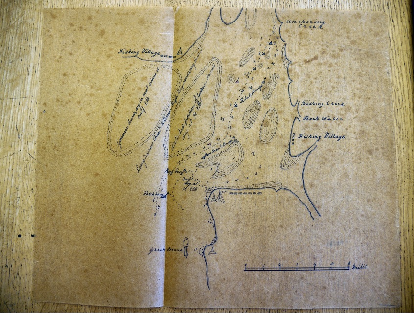
Remarks
We left Fairway buoy Rangoon River at nearly high water and therefore carried on Ebb tide across the Gulf to Amherst Point and found us at 0340 13th to the south and a little off the double Island Light which was bearing E by N. It is a fixed light of great brilliance and visible for 18 nautical miles . At daybreak the high land of Armhurst island and mountains were very quickly sighted. The double island when bearing to the north of east appears as two islands. The northern part having the white light house on it..
We arrived at the Patch Buoy at ( Iron, staff and ball) at about 0800 high water having taken a pilot a short distance outside.
Vessels should never enter or attempt the river without a pilot as the buoys are constantly being shifted on account of the alteration of the sand.. The pilot station is at Amherst Point but there is generally a schooner off Green island. The starboard side of the channel entering is distinguished by (black) iron buoys, every third with staff and ball. The port side is red (iron buoys) but only two. The reef (B) buoy is the second on or first after passing the Patch Buoy. The channel at present is up the east side between shoals crossing over to Natmo Point above which 2 or 3 miles are two iron buoys (red) marking the Clifford Rocks. Here it is where we had least water, only having 3 ¼ fathoms and drawing 18 feet 2 inches aft. The tide had of course fallen. From there we crossed over to docks and timber yards and steamed up to Government Wharf – a fine iron pier. The mail ships do not use this but go to a wooden one. A very few ships and mostly all timber ships. Pagodas are to be seen in all directions on the highest hills and some even built on rocks. The east bank is with houses (Native) the front of which forms the Main Street which runs parallel with the river. The upper part of this river is called the Salsrein(?) and is not navigable for any great direction.. The breeze set in regularly at noon from the the south and west hauling to the westward towards Sunset. this was generally the case at Rangoon, setting in very strong. The land breeze being very light from the eastward. High water at Maulmain is two hours later than at Amcherst