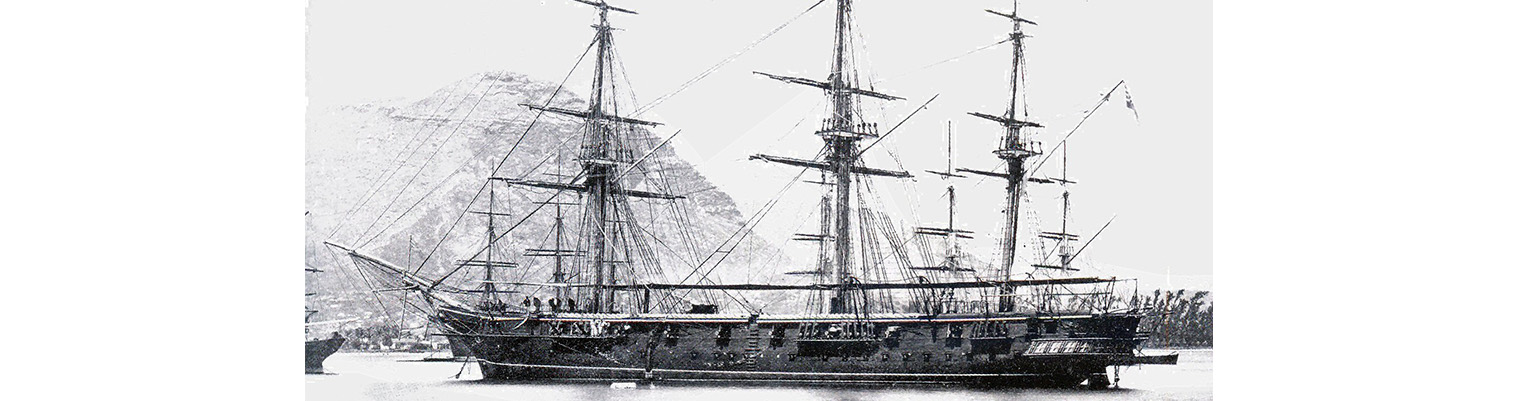
This is the story of the second ship to bear the name HMS Cossack.

Originally ordered by Russia for the Black Sea Fleet in December 1852 at a cost of 290,000 silver roubles, the ship was sold to the Hamburg trading house of Henry Mersk & Co. when relations between Britain and Russia deteriorated, as Russia feared possible confiscation.

The original contract price for the vessel, then named Witjas (Cossack), was £46,198, including £16,750 for machinery. The Admiralty subsequently paid the contractors £9,591 to complete the contract (of which £4,187 was for machinery), plus £751 for tonnage exceeding the specification and £2,206 for modifications for His Majesty’s service. The ship remained in service until 1875.

Year by Year

Discover the history of the HMS Cossack from 1854 to 1875.

You can search the ‘year’ and ‘month’ to find a specific date and also ‘click’ on the date itself to reveal any images and moments from that date.

26 July 1872

Latitude 15.25S. Longitude 170.55W. Course S12W. Wind south easterly force 2  becoming SE by E force 3. Under sail.

Employed as most requisite

27 July 1872

Latitude 16.9S. Longitude 171.37W. Course S40W. Under sail.

28 July 1872

Latitude 17.52S. Longitude 172.47W. Course S33W. wind ESE force 3 becoming ESE force 2. Under sail. Fine weather.

Performed Divine Service

29 July 1872

Latitude 19.22S. Longitude 173.22W. Course S20W. wind ESE force 3 becoming light airs. Under sail.

Noon. Altered course to the south. Small arms men at drill.

1800. Up steam. Proceeded with Fore and aft sail and steam steering SSW. Strong westerly current.

30 July 1872

Latitude 20.58S.longitude 174.34W. Course S36W.  Wind southerly force  1 becoming calm and  light airs. Under steam.

0900. Altered course to SW and sighted the Island of Eua at 0930.

Noon. Euaigee Island S62W 19 miles.

1400. . Sighted Tongatabu.

1545. Took in pilot (Native). 1740. Anchored off Nakalofa, (Nukualofa) Tongatabu in 12 ½ fathoms. Anchor bearings  Church SSW. Pomgimode E ¾ N.


Remarks

We came up through the eastern passage arriving at the small port with the rock (sunken) …

Latitude 20.58S.longitude 174.34W. Course S36W.  Wind southerly force  1 becoming calm and  light airs. Under steam.

0900. Altered course to SW and sighted the Island of Eua at 0930.

Noon. Euaigee Island S62W 19 miles.

1400. . Sighted Tongatabu.

1545. Took in pilot (Native). 1740. Anchored off Nakalofa, (Nukualofa) Tongatabu in 12 ½ fathoms. Anchor bearings  Church SSW. Pomgimode E ¾ N.


Remarks

We came up through the eastern passage arriving at the small port with the rock (sunken) where boarded by the pilot who took us up the eastern side of rock. Three whaling ships were at anchor who kept their boats employed in the offing during the day looking for whales in which occupation they seemed to be successful. The High waters Fl and Ch appeared to be later than that given in the charts and that given by Mr Duncan of HMS  Zebra seemed to be nearer the mark –  viz 8 hours. The Wesleyan Church is on the highest part of the island and the flag staff and the king’s house below it to the eastward.

31 July 1872

1740. Anchored off Nukalofa, Tongatapu (Tongtapu. Tonga). Wind ENE becoming NE force 2. Barometer 30.18 inches. Maximum temperature 78F.

Crossed Top gallant yards and loaded sails.

01 August 1872

Wind ENE force 2 becoming NNE force 2.

1000. King george of Tonga visited ship accompanied by his interpreter. Received him with manned yards and saluted him on leaving with 21 guns.

1600. Left the anchorage under steam a direct course taking a vessel out out clear from the anchorage.

1800. Made all plain sail on starboard tack. Mallenoak S57E. Polva S24W, Stopped steaming. Shaped course WN ½ N

2 August 1872

Latitude 20.38S. Longitude 176.10W. Course N69W. NNE force 2 becoming north easterly force 1. Under sail.

Exercised at General and Fire Quarters. Set starboard Topmast and Top gallant stud sails. Lightening from the eastward with rain.

03 August 1872

Latitude 20.20S. Longitude 176.58W. Course N68W.  Wind north easterly force 1 becoming NE by E force 2 Under sail.

Employed cleaning ship throughout.

0945. Passed a vessel standing to the northward; supposed to have been a Man of War . Most probably the USS RESACA

04 August 1872

Latitude 20.1S. Longitude 178.19W. Course N75W. Wind  NNE force 4 becoming NW by W  force 3. Wind at 0900 shifted to the westward from NNE  veering to the SW. Under sail. Barometer 30.06 inches. Maximum temperature 82F. 0645.

Observed land (Turtle Island) on starboard bow bearing NE by N. Noon. Turtle island north agreeing within 3 miles being that too much to the westward.

1420. Turtle island NE by N. Lost sight of Turtle Island.

Midnight. Wind southward with slight drizzling rain.

05 August 1872

Latitude 19.7S. Longitude 179.54W. Course N59W.  Wind SSW force 3 to 4 becoming SSE force 4. Under sail. Barometer 30.17 inches . Maximum temperature 75F.

0730. Observed land ahead ( Totoya).

0800. Wind veered to the south eastward force 4  with fine weather.

1010. Sighted Matautu WSW. Altered course to West.

Noon. South Point S64W North Point Totoya N13W.

1240. Altered course to NW by W to pass between islands of Matautu and Totoya.  Levuka observed . Spot bearing N40W 113 miles.

1600. Moala…

Latitude 19.7S. Longitude 179.54W. Course N59W.  Wind SSW force 3 to 4 becoming SSE force 4. Under sail. Barometer 30.17 inches . Maximum temperature 75F.

0730. Observed land ahead ( Totoya).

0800. Wind veered to the south eastward force 4  with fine weather.

1010. Sighted Matautu WSW. Altered course to West.

Noon. South Point S64W North Point Totoya N13W.

1240. Altered course to NW by W to pass between islands of Matautu and Totoya.  Levuka observed . Spot bearing N40W 113 miles.

1600. Moala extreme NE by N.  Matuku. West extreme S by E.  Lost sight of Totoya.

1830. Altered course to NW by W ½ W.

1700. Shortened sail as requisite.

06 August 1872

Wind ESE force 4 becoming SE by E force 3..

0100. Altered course to N ¾ W.

0320.  Shortened sail to Fore topmast staysail and altered course to the north.

0400. Down screw and furled sails.

0445. Commenced steaming dead to wind to keep position until daylight. The morning being thick and no land in sight. Wind ESE force 3 to 4.

Daylight. Mbatiki N44W. Oraulau N44W. Proceeded NW by N for Levuka.

0850. Came to with sandy bottom in 16 fathoms  and veered to 48 fathoms.  At single anchor in Levu…

Wind ESE force 4 becoming SE by E force 3..

0100. Altered course to N ¾ W.

0320.  Shortened sail to Fore topmast staysail and altered course to the north.

0400. Down screw and furled sails.

0445. Commenced steaming dead to wind to keep position until daylight. The morning being thick and no land in sight. Wind ESE force 3 to 4.

Daylight. Mbatiki N44W. Oraulau N44W. Proceeded NW by N for Levuka.

0850. Came to with sandy bottom in 16 fathoms  and veered to 48 fathoms.  At single anchor in Levuka Harbour. Found here French Gunboat VANDREL. Out boom boats. Down upper yards. Unbent sails.

07 August 1872

Wind SE force 1 becoming south easterly force 2.

Employed as most requisite.

08 August 1872

8 August 1872. Wind SE force 3 becoming ESE force 2. Maximum temperature 81F.

Employed scrubbing masts and yards. Sailmakers repairing main topsail.

09 August 1872

Wind SE force 2 becoming ESE force 2.

Exercised at General Quarters. Carpenters repairing cutter.

10 August 1872

Wind ESE force 3 becoming south easterly force 3.

0820 French Gunboat VANDREL sailed.. employed cleaning ship.

11 August 1872

Wind SE by E force 2 becoming easterly force 2.

Performed Divine Service.

12 August 1872

Wind Easterly becoming north easterly  force 2.

Passing showers. Party of men ashore firing at butts.

13 August 1872

Calm and light airs becoming north easterly  force 2. Barometer 30.16 inches.

Training party at rifle drill. Placed schooner ISLE OF BEAUTY under embargo. Watering ship by launch.

14 August 1872

Wind calm becoming north easterly force 1. Maximum temperature 86F. 0755.

Bent sails. Crossed Royal yards and loosed sails. Sailmakers repairing main topsail.

1040. Furled sails . Down upper yards.

Hidden Gems

The Island of Kotka was attacked in 1855, but the garrison had already departed: barracks, stores and magazines etc were destroyed and the squadron left, leaving COSSACK in charge of the Island.

Anchor crest

Receive our newsletters?