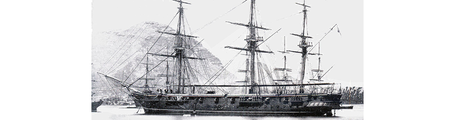
Year by Year
Discover the history of the HMS Cossack from 1854 to 1875.
You can search the ‘year’ and ‘month’ to find a specific date and also ‘click’ on the date itself to reveal any images and moments from that date.
10 June 1872
Calm then southerly force 1 becoming south force 1 to 2.
Employed as requisite.
Remarks
During our stay which was close on a month we had the SE trade wind nearly the whole time. Generally from SSE hauling to the eastward as the day advanced with the barometer steady at a mean 30.06 inches. Temperatures – before our arrival here they had the same weather as we had a at Matuku which is considered rather unusual at this time. Occasionally the wind was from the westward and NW with rain and increasing the rain very much.
The beacons are not so conspicuous as you might wish for; they being small; about the size of a sentry box; and of slate colour with a red diamond painted on the front face. We were puzzled in trying to make them out on the Harbour Master (Whom we had taken onboard but did not avail ourselves of his aid) alluding to them.
A pilot came off in a whaler boat but we did not require him and then we gave him a tow in. Shortly afterwards the Government pilot and harbour master came off and who was allowed on board on our seeing he carried the Fijian Flag. (Blue and white perpendicular with a red crescent and a white dove with a sprig in its mouth in the centre)
[Current flag
The Union Jack (upper left), is representative of the country’s long association with Great Britain. The flag’s blue field is symbolic of the surrounding Pacific Ocean. The coat of arms display a golden British lion holding a cocoa pod, as well as panels displaying a palm tree, sugar cane, bananas and dove of peace.]
He gave us to understand we could not take a position abreast of the Kings Pier on account of our being in the way of the traders of the place which was ridiculous
The reef is well defined at the entrance and dry in several places at low water. Also the bank in the centre of the harbour dries at low waters and a rock to the northward of the town about a cables length off shore is awash at low water.
11 June 1872
Wind SSE force 2 becoming SE by E force 1 to 2. Barometer 30.02 inches. Preparing for sea.
1200. Weighed under sail with light SSE wind and beat out in 2 ½ hours.
1330 Shaped course to north to pass through Wakaia (Wakaya) Island.
1600. Pottage Island NW. Mokongai NE.
1800. Point Makindrage E by S and Pottage Island west.
2200. Passed through channel which people said was impossible for large vessels to go through owing to a strong current but we did find such to be the case.
Midnight. Wind fell calm.
14 June 1872
1330.Weighed under steam for Vuna Point. Wind southerly force 1. Barometer 30.12 inches. Light southerly wind.
0350. Observed land on port bow. Wind fell, furled sails and commenced steaming on E by N.
1315. Stopped and sent cutter sounding.
1330. Came to off Tarruna (?) Island with broken bottom in 32 fathoms and veered to 4 ¾ shackles. Anchorage bearings Coralib Island N22E. Vuna Point south.
Remarks
At Savu Savu there was a large store and ginning establishment and boat building shed which is considered the dockyard of Fiji. There are also a great many plantations more inland. The whites numbering about 200. Taveuni Island is considered the finest islands in the group and in consequence has a great many plantations. It is certainly the best in appearance. The weather during our stay was generally cloudy with occasional heavy showers. The wind veering from North, NNW to SSE and always light. The reef off Vuna Point showed out very plainly. At our anchorage we swung in 55 fathoms ( Coral) and inshore appeared to be foul ground. Better off we should not anchor in less than 30 fathoms.
