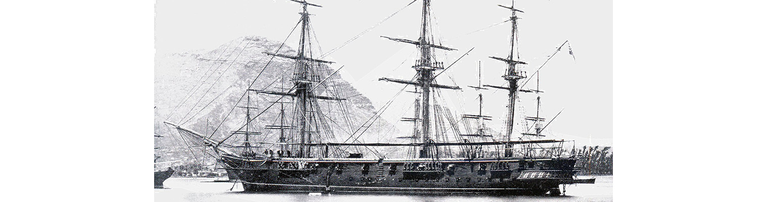
Year by Year
Discover the history of the HMS Cossack from 1854 to 1875.
You can search the ‘year’ and ‘month’ to find a specific date and also ‘click’ on the date itself to reveal any images and moments from that date.
07 May 1872
Latitude 19.29S. Longitude 178.7E. Course N24E. Wind easterly force 2 becoming NE by N force 3. Under sail.
0825. Sighted Mount Washington, Kandavu Island NW. This mountain is very conspicuous owing to its great height. As luck would have it the wind headed and at noon came from the NE force 4 for if the wind had remained in the eastward we might have easily weathered the Island.
1410 Tacked. Stood ESE.
1830 Proceeded under steam. Furled sails. Housed Top gallant masts. Midnight Wind NE by N . Course ENE
08 May 1872
Latitude 19.21S. Longitude 179.27. Course N84E. Wind N by E force 3 becoming NW force 1 to 4. Under sail and steam. Maximum temperature 84F 1500.,.Lightening to Northward.
0730.Observed a schooner to NW.
0800. In fore and aft sail. Altered course to N ½ W. Wind N by E force 3 to 4. Sighted Matuka Island NE.
0900. Making very little headway against wind and sea . Made sail on port tack. Wind shifting to NW.
1235 sighted Moala Island NNE.
1400 Shortened and furled sails.
1430 Stopped and came to in Matuku Harbour Matuku Island with sandy bottom in i8 fathoms and veered to 2 ½ shackles. Anchorage bearings ( Magnetic) Kara Levu N85E. ????? Island N40W. Wind NW with heavy showers.
Remarks
The prevailing winds during our passage have been from the westward and northward and no trade wind which was although the Directions say are seldom found to the westward might have been expected and were looked for. On our leaving we has the first day a strong set to SSW of 20 miles but the next day although we had only a light wind we found a tremendous current of 40’ to NW taking us in sight of of the coast. After that we were generally set to the eastward and northward on an average of 15 miles per day. On the day of our sighting Kandavu as will be seen by data there was scarcely any set but the next day in standing to the eastward we were set S by E 22 miles placing us in the same latitude as the day before. The view of the Island of Matuku is very good. The centre peak of Kara Levu being easily made out.
The course east through the Herald leads rather close to Norths edge of shoal and E ¾ N course leads through and by which we went in by (Kara Levu E ¾ N) the surf was seen breaking heavily on the reef as far as we could see from the masthead. The rock on the SW corner of North reef was just awash. The bottom was just seen on the outside edge of the reef very plainly, but quite clear in mid-channel.
The natives came off in great numbers in their small canoes, ringing off pigs, fowls, yarns and fruit which they sold for coppers and soap. Several of the officers went to see the chief and were well received by the natives. The Wesleyan Mission had a native missionary here sent from the Island of Lakimba.
10 May 1872
Wind calm with light airs becoming NW force 2 to 4. Eight of Solomon Islanders swan ashore. Stern guns firing at an object on the shore.
0900. Wind springs up from NNW. With heavy and threatening looking weather accompanied with very heavy showers of rain and at times squally from NW.
1600. Ship having dragged derig a squall and therefore close to reef astern.. Weighed under steam and anchored with Broken bottom in 18 fathoms veering to 3 shackles. Wind NW force 3 to 4. Anchorage bearings Haro-Levu N85E. Valanga island N33W. heavy rain and lightning to the north westward.
