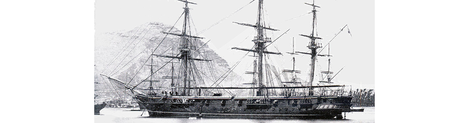
This is the story of the second ship to bear the name HMS Cossack.

Originally ordered by Russia for the Black Sea Fleet in December 1852 at a cost of 290,000 silver roubles, the ship was sold to the Hamburg trading house of Henry Mersk & Co. when relations between Britain and Russia deteriorated, as Russia feared possible confiscation.

The original contract price for the vessel, then named Witjas (Cossack), was £46,198, including £16,750 for machinery. The Admiralty subsequently paid the contractors £9,591 to complete the contract (of which £4,187 was for machinery), plus £751 for tonnage exceeding the specification and £2,206 for modifications for His Majesty’s service. The ship remained in service until 1875.

Year by Year

Discover the history of the HMS Cossack from 1854 to 1875.

You can search the ‘year’ and ‘month’ to find a specific date and also ‘click’ on the date itself to reveal any images and moments from that date.

16 February 1872

Latitude 35.37S. Longitude 110.52E. Course S52W.  Wind SSE force 4. Under sail. Barometer 30.31 inches. Maximum temperature 66F. Northerly current.

17 February 1872

Latitude 36.50S. Longitude 109.16E. Course S47W. Wind south force 2 to 3 becoming SSW force 3.

Under sail. 1000. Wind hauled round to SSW, went about and stood SE by E. We had stood as far as 109E and latitude 37S before picking up the westerly wind.

18 February 1872

Latitude 37.12S. Longitude 110.38E. Course S71E. Wind SSW force 2 becoming WSW force 2.  Under sail. Barometer 30.13 inches. Heavy south westerly swell.

19 February 1872

Latitude 38.5S. Longitude 113.2E. Course S65E. Wind SSW force 4  becoming southerly force 3.Under sail. Barometer  rising 30.32 inches.

Employed as  most requisite and repairing sails. Wind hauled to the SSE.

20 February 1872

Latitude 37.54S. Longitude 114.13E. Course N79E. Wind light airs from SE becoming variable. . Under sail. Barometer 30.38 inches. Heavy swell from westward.

21 February 1872

Latitude 37.51S. Longitude 114.36E. Course N79E. Wind light easterly  airs becoming ENE force 1. Under sail. Barometer falling – midnight 29.96 inches. SW  swell.

22 February 1872

Latitude 38.8S. Longitude 115.26E. Course S66E. Wind light and variable becoming SW force5.

Under sail. Barometer 29.87 inches dropping to 29.78 inches. Maximum temperature 66F.  south Cape Tasmania S77E 1549 nautical miles. Light airs fro NE during the forenoon. Shifted to north westward gradually hauling round to SW force 6 to 7. Squally and passing showers.

23 February 1872

Latitude 39.32S. Longitude 118.35E. Course S60E. Wind SW 6 decreasing to 4 later. Under sail. Maximum temperature 57F. Breeze steady.

Employed as most requisite.

24 February 1872

Latitude 40.30S. Longitude 121.44E. Course S68E. Wind SW force 3 to 4 becoming westerly force 3. Under sail. Barometer 30.27 inches. Heavy westerly swell

25 February 1872

Latitude 41.17S. Longitude 124.7E. Course S67E. Wind NW by W force 3 becoming NW force 2 to 3. Under sail.

2000. Observed a very brilliant meteor.

26 February 1872

Latitude 42.9S.  Longitude 126.14E. Course S61E.  Wind northerly  force 5 becoming NNE force 4.. Barometer 30.44 inches.

It was most remarkable the smoothness of the sea with the fresh breeze from the north eastward. The ship even going 9 knots.

27 February 1872

Latitude 43.39S. Longitude 130.12E. Course S65E. Wind NNE force 4 becoming NE by N force 4 to 5. Under plain sail. Cloudy and misty weather..

28 February 1872

Latitude 44.5S. Longitude 134.38E. Course S79E. Wind north force 6 becoming NW force 3 Under all plain sail and port stud sails. Cloudy and misty weather. Exceedingly heavy dews at night.

29 February 1872

Latitude 44.11S. Longitude 137.32E. Course S87E. Wind NW 3. Under sail. Barometer 30.30inches. maximum temperature 58F. South Cape Tasmania N86E 421 nautical miles.

Noon. Altered course to E by N.

01 March 1872

Latitude 44.00S. Longitude 13950E. Course N83E. Wind north force 2 becoming 3 to 4.

Under sail. Began to feel the south westerly swell. Weather misty and cloudy with heavy dews at night.

02 March 1872

Latitude 43.45S. Longitude 143.38E. Course N85E. wind north force 4 becoming NNW force 4.

Under plain sail. Very thick fog which prevents getting sights for the latitude or longitude and did not clear away until about 1400. This enabled sights for latitude and longitude to be taken. These almost agreed with the dead reckoning.

Noon. Altered course to east.

1530. Sights showed a westerly drift of about 10 miles. Strong breeze from NNW clearing fog. Barometer steady. Bent cables.

2000 Altered cour…

Latitude 43.45S. Longitude 143.38E. Course N85E. wind north force 4 becoming NNW force 4.

Under plain sail. Very thick fog which prevents getting sights for the latitude or longitude and did not clear away until about 1400. This enabled sights for latitude and longitude to be taken. These almost agreed with the dead reckoning.

Noon. Altered course to east.

1530. Sights showed a westerly drift of about 10 miles. Strong breeze from NNW clearing fog. Barometer steady. Bent cables.

2000 Altered course to E by S.

03 March 1872

Steaming up D’Entrecsteaux Channel.

1900 anchored in Apollo Bay. Wind south easterly force 4 becoming ENE force 3. Barometer 30.37 inches . maximum temperature 59F.

0200. Wind hauled round to SW and southward force 5 to 6. In first and second reefs of Top sails. Barometer 30.14 inches and rising.

0500. Altered course to ENE.

0600. Out reefs and made to Top gallant sails.

0610. Sighted Menstone rock NNE 80.

0620 Up steam under both boilers.

0845. Sighted South Cape NE.

0900 commenced steaming. …

Steaming up D’Entrecsteaux Channel.

1900 anchored in Apollo Bay. Wind south easterly force 4 becoming ENE force 3. Barometer 30.37 inches . maximum temperature 59F.

0200. Wind hauled round to SW and southward force 5 to 6. In first and second reefs of Top sails. Barometer 30.14 inches and rising.

0500. Altered course to ENE.

0600. Out reefs and made to Top gallant sails.

0610. Sighted Menstone rock NNE 80.

0620 Up steam under both boilers.

0845. Sighted South Cape NE.

0900 commenced steaming. Shortened and furled sails. Set fore and aft sails.

1035. Sighted the Eddystone rock E by S. Course NE by E.

1200. In fore and aft sails.

1300. Sighted Bruny Island Lighthouse N16E. Course N by E.

1430 Altered course for D’Entrecsteaux Channel.  .

1500. Lighthouse Bruny Island N64E.

1600. North end of Partridge Island NE.

1850. Stopped and anchored in Apollo Bay in 9 ½ fathoms with sandy bottom. Veered to 2 shackles.

Midnight. Wind although not too fresh followed us around to SE, NE and was then light from the NNE.

04 March 1872

0515. Steamed up the Derwent River to Hobart. 0900. Anchored in Apollo Bay Tasmania . Wind north force 3 becoming SSE force 1 to 2. Maximum temperature 76F.

0500.Weighed and proceeded under steam for northern entrance of channel.

0840. Came to in Sullivan’s Cove in 12 fathoms with sand bottom. Flagstaff of Prince Alberts Battery and Signal Hill in one.


Remarks.

Swan River to Hobart Town

This passage has taken an unusually 21 days and on the whole experienced fine weather with one or two…

0515. Steamed up the Derwent River to Hobart. 0900. Anchored in Apollo Bay Tasmania . Wind north force 3 becoming SSE force 1 to 2. Maximum temperature 76F.

0500.Weighed and proceeded under steam for northern entrance of channel.

0840. Came to in Sullivan’s Cove in 12 fathoms with sand bottom. Flagstaff of Prince Alberts Battery and Signal Hill in one.


Remarks.

Swan River to Hobart Town

This passage has taken an unusually 21 days and on the whole experienced fine weather with one or two exceptions. One started with a SE wind with which we stood off from the Cape Leeuwin about 200 miles and on our 5th day out in latitude 36.40S the wind hauled round to SSW and SW force 3 which we held for a week with two days of balmy light and variable airs from SE, eastward and northward. The remainder of the time north westerly and occasionally backing round to the eastward. He highest barometer was 30.44 inches with a northerly wind and had seldom been lower than 30.00 inches during the passage. The highest with southerly wind 30.38 inches.

Off the Cape Leeuwin we felt the westerly current of about 1 knot and then for only one or two days and then with southerly wind a NE by easterly current for 7 days at about 20 knots per day on average and with the northerly wind a current setting E by S and S51W for 2 days at 10 knots per day.. March 3. A current had set us west nearly 2 ½ knots per hour and consequently we only sighted the Menstone Rock at 0600 and South Cape at 0845. Maatsurykest (?) and Needle rock were sighted – the former a wedge shaped island sloping to the coast. at 1035. Sighted the Rocks of Pedra Blanca and Eddystone – the latter resembling a tower or pillar. Bruny Lighthouse 335 feet high visible 22 miles revolving every 20 seconds.

The Channel of  D’Entrecsteaux is not recommended for sailing vessels except in the summer season owing to the contrary  direction given to the winds from the high hills and the openings. Therefore the passage by Storm Bay is strongly advised. We passed up mid channel nearly the whole way; the only danger being the Actaion Shoals which were seen breaking heavily. The Whirlpool Rock on which is moored a black can buoy which we passed on our port hand side and the Bank between the Three Huts and  Cape (???) Point which is also marked by beacons, and by bearings on the other shore it is easily passed. Not being able to fetch in Hobart Town by light anchored  in Apollo Bay ( About 20 miles from the town)in ten fathoms (mud). The channel which is about 30 to 40 miles long varies from 4 miles within the entrance to ½ mile at the northern entrance. With plenty of water and beautiful scenery with several villages and farms. Next morning stood up channel and were telegraphed up to Hobart Town by signal from Mount Louis, Point Pierson. A pilot came off but he was not wanted.. Passed a whaler at anchor a few miles south of the town. they generally appear to call for provisions. A very few vessels in harbours. Two steamers run to Melbourne and Sydney weekly

06 March 1872

Wind northerly force 2 becoming NW force 2 to 3.

Out boom boats. Fired shot, shell and rockets.

07 March 1872

Wind NNW force 3 becoming SE force 2. Barometer 30.09 inches. Maximum temperature 88F.

His Excellency The Governor M’ Du Lave visited the ship. Saluted and manned the yards.

Hidden Gems

The Island of Kotka was attacked in 1855, but the garrison had already departed: barracks, stores and magazines etc were destroyed and the squadron left, leaving COSSACK in charge of the Island.

Anchor crest

Receive our newsletters?