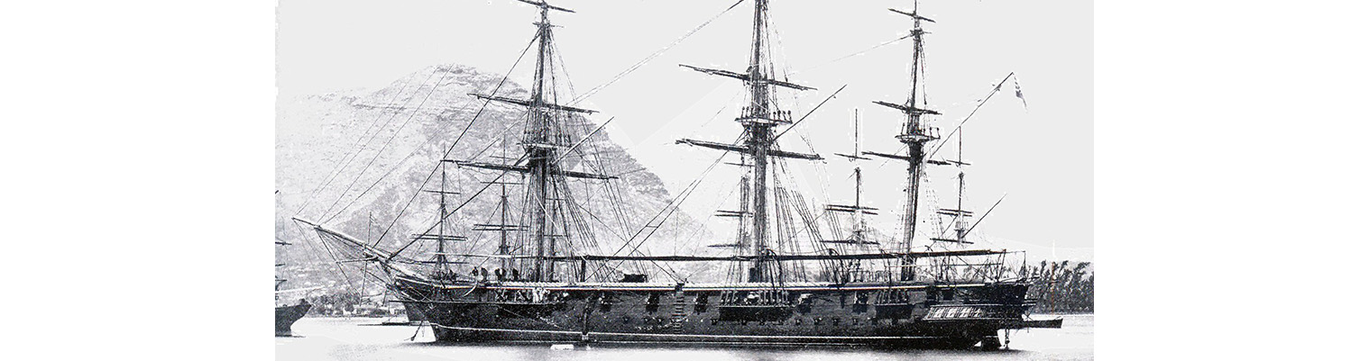
Year by Year
Discover the history of the HMS Cossack from 1854 to 1875.
You can search the ‘year’ and ‘month’ to find a specific date and also ‘click’ on the date itself to reveal any images and moments from that date.
22 December 1871
Latitude 20.29S. Longitude 114.51E. Course N34E. Wind S by E force 4 becoming east force 1.Under sail. Maximum temperature 84F.
1410. Light wind . Proceeded ahead under steam. Surveying cables and re-storing them.
1655. Sounded in 30 fathoms.
1700 Passed over the position of Ritchies Reef as shown in Admiralty charts 1055 Australia west coast sheet 7. Latitude 20.17S. Longitude 115.7E and sounded in 44 fathom (Fine white sand.)
1740. Altered course to eastward to sight reef as placed by Captain Stokes 16 miles eastward.
1850 Sounded in 32 fathoms.
2000. Altered course to north. Sounded in 25 fathoms.
2005. Sounded in 18 fathom – hand lead 13 fathoms.
2010. Altered course to SW. Sounded in 27 fathoms.
2325. Altered course to north
24 December 1871
0330 Observed Legendre Island two points before starboard beam.
0510. Altered course to E by S.
0800. Byout S6E. North Point of Delambre Island S85W.
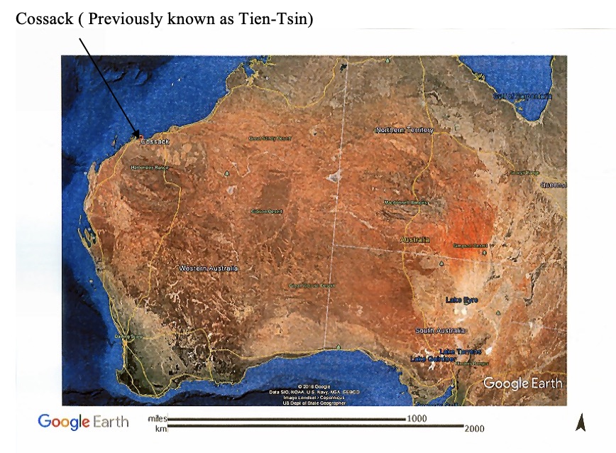
1050. Came to in 5 ½ fathoms with broken bottom, sand and shingle. Veered to 3 shackles. At single anchor in Tien-Tsin Harbour Cape Lambert. Visit to Tien Tsin Harbour, Australia with Governor Sir Fredrick Weld. Town was then renamed “COSSACK” (See later article on town of Cossack) Wind SE force 2 becoming NW force 2. Barometer rose from 29.85 inches to 29.92 inches. Maximum temperature 87F.
26 December 1871
Wind west force 2 becoming WNW force 2.landed on Cape Lambest and found position to agree with chart. It is very low and flat point ending in cliff down to the shore. Water shoaled very gradually towards the point and found there was a deep bay about a mile wide west of the Cape with a dangerous reef of rocks running out and not marked on the chart. No vessels save coasters visit this place and they are all small vessels who go up the mouth of the river which is beaconed off and accessible over the bar at high water.
02 January 1872
Wind north easterly force 3. Wind still from NE. Gave up the idea of going to Turtle island. Prepared for sea. The prevailing wind appears to be from NW with fine weather, but strong easterly gales happen here about at about this season and this time last year the place was visited by a tremendous hurricane from the eastward which swept away everything moveable before it – even lifting the roofs of houses at Roeburn. The height of rise of tide is given as 18 feet but I should think it was considerable more at spring tides by the way the reefs were left dry at low water.
The pearl grounds are situated of Condon Creek a few miles from Breaker Inlet and 22 from North Turtle Island where we were to have anchored and then sent a boat in through the banks which no boat should attempt without a pilot or person acquainted with the place as the rise and fall is said to be 24 feet.
1230. Weighed under steam and proceeded to the north westward. Light NE wind.
1600. Begout Island – south. North Point Delambri – west.
1700. Made sail to Top gallants. Stopped steaming. Raised screw.
1830 sounded in 26 fathoms – course shingle and sand.
2130 . sounded in 26 fathoms – grey sand. Both Begout and Delambri islands are low and quite bare. The north end of Delambri forms a smaller cliff with a sandy shore. Flat Rock situated to the NNE of Picard Island is well
03 January 1872
Latitude 20.12S. Longitude 115.35E. Course N87W. Wind NE force 2 becoming light and variable. Under both steam and sail. Maximum temperature 89F.
0030. Sounded in 27 fathoms ( Sand and shingle) Light northerly wind. Sounded at 0130, 0230, 0330. In 26 fathoms. ( Sand and shingle)
0615. Commenced steaming. Light north easterly wind.
0900. Observed land on port bow WSW which were the Monte Bello Islands and by the chart Ne 1055 Sheet 7 NWC distant about 30 miles and by Stokes position of the islands about 15 miles. The latter certainly appears correct as it is very improbable we should have seen them at a greater distance.
Noon. Assumed position of Ritchies Reef S86W 14 miles (latitude 20.15S.Longitude 115.22E) North point of Trimouille S12W. ritchies Reef latitude 20.16S. longitude 1150 22’ 30”E.
1230. Sighted Ritchies Reef breaking heavily WSW.
[Tryal Rocks, sometimes spelled Trial Rocks or Tryall Rocks, formerly known as Ritchie’s Reef or the Greyhound’s Shoal, is a reef of rock located in the Indian Ocean off the northwest coast of Australia,] Bearings – hill Trimouille S11E. North extreme of land S5E. alatered course west.
1300 Hill Trimouille S30E. Sounde 24 fathoms ( sand, shingle). North breakers of reef S24W.
1330. Sounded in 20 fathoms ( coral, shingle) North breakers 1350. South breakers. Hill Trimouille S52E.
1430. Reef bore S86E. Longitude by chart 115010’ 30”. Altered course to SW ½ W.
1445. Lost sight of Richies Reef. The reef, although known by the coasters and others to out of its position, there has never been a chance of verifying the position as given by Captain King in the Admiralty Charts and Directions; although a small note ( Volume 3 W.A. Directory- page 164) infers that Captain Stokes a few years later placed the above reef and Monte Bello 16 mile to the eastward and whose positions have now been found correct as regards the reef and islands and placed by Navy Lieutenant E.O Hallett as Latitude 20.16S. Longitude 1150 22’ 30”. Bearing from hill of Trimouille Island N52W 14 miles. Our position on the night of 22 December 1971 on shoaling suddenly from 26 to 13 fathoms must have placed us within a short distance of the Ritchie Reef. For this day the least we was 24 fathoms ( coral, shingle). From the masthead the reef’s appeared in two parts breaking heavily but nothing dry.
1620. Sounded in 40 fathoms ( grey sand). Longitude 115.14E.
1840. Sounded in 40 fathoms (rock). Lightning to south and east. Swell from south westward.
2100 exercised at Night Quarters.
2315. Shortened and furled sails. Wind light from SW.
