This is the story of the second ship to bear the name HMS Cossack.

Originally ordered by Russia for the Black Sea Fleet in December 1852 at a cost of 290,000 silver roubles, the ship was sold to the Hamburg trading house of Henry Mersk & Co. when relations between Britain and Russia deteriorated, as Russia feared possible confiscation.

The original contract price for the vessel, then named Witjas (Cossack), was £46,198, including £16,750 for machinery. The Admiralty subsequently paid the contractors £9,591 to complete the contract (of which £4,187 was for machinery), plus £751 for tonnage exceeding the specification and £2,206 for modifications for His Majesty’s service. The ship remained in service until 1875.

Year by Year

Discover the history of the HMS Cossack from 1854 to 1875.

You can search the ‘year’ and ‘month’ to find a specific date and also ‘click’ on the date itself to reveal any images and moments from that date.

05 November 1871

Latitude 38.42S. Longitude 76.4E. Course N78E. Wind north force 4 becoming NNW force 4. Under sail.

Performed Divine Service. Weather as for the 4th. St Pauls Island east 109 nautical miles. In second reefs and top gallant sails. Shortened sail as required for sighting the Island of St paul by daybreak. Bent cables

06 November 1871

Anchored off St Pauls Islands – at single anchor. Wind north westerly force 4 becoming NNW force 4. Barometer 30.36 inches. Maximum temperature 59F.

0415. Made sail.

0445. Sighted the island of St Paul bearing SW. Trimmed sails. Shaped course SSW. Shortened sail and came to in 20 fathoms abreast of Crater Lake with broken bottom and veered to 76 fathoms.  Anchorage bearings. Ninepin Rock N55W magnetic. Hutchinson’s Point S15W magnetic.

The after part of the wreck of MEGARA is still to be se…

Anchored off St Pauls Islands – at single anchor. Wind north westerly force 4 becoming NNW force 4. Barometer 30.36 inches. Maximum temperature 59F.

0415. Made sail.

0445. Sighted the island of St Paul bearing SW. Trimmed sails. Shaped course SSW. Shortened sail and came to in 20 fathoms abreast of Crater Lake with broken bottom and veered to 76 fathoms.  Anchorage bearings. Ninepin Rock N55W magnetic. Hutchinson’s Point S15W magnetic.

The after part of the wreck of MEGARA is still to be seen right on the bar with the four boilers awash in about 1 to 2 fathoms of water outside but nothing could be seen of the rest of the hull having fallen in to  the deep water of the Crater lake on the bar. Ballast cables etc were never seen. The two Frenchmen of the island hoisted French Colours. They say that on the same day the men left in the MEGARA  a gale from the SE drove her u further and also parted on the 6 September. Captain and officials landed and found great quantities of stores of all  descriptions. Took shore observations for errors of chronometers and found they had kept their old rates from the Cape notwithstanding the cold weather.  Lowered the screw.

07 November 1871

Wind north force 5 to 6 becoming south westerly force 3 to 4. Barometer 30.32 inches.

0430. Light fire under port boiler for the purpose of picking up an inshore billet but owing to a fall in the barometer and strong northerly wind we did not weigh. Towards noon the shafted suddenly to the SW with a rapidly rising barometer. Kept anchor watch.

08 November 1871

Wind westerly force 2 becoming southerly force 2. Barometer 30.56 inches.

0600. Weighed and shifted berth under steam. Anchored in 9 fathoms with sandy bottom and veered to  two shackles. Out boom boats. Anchorage bearings Ninepin Peak N22W. Hutchinson’s Point S18E. Picket on shore and working party shipping off stores. Employed hoisting in and stowing stores.

Midnight Wind  light airs. Barometer 30.31 inches.

09 November 1871

Wind NNW force 2 becoming northerly force 3 to 4.

Employed as per the 8th. Engineers and stokers clearing away screw from hull. Wind shifted to the northward force 4. Veered cable to three shackles. Lit fires under starboard boiler.

10 November 1871

Wind northerly force 3 becoming north force 3. As the 10th.  Dismantling tents.

1900. In boom boats.

There appeared to be no fresh water on the island except from the place used by the MEGARA which is on the summit of the hill  a short distance from the huts.  Fish were caught in great quantities in both anchorages but nothing was to be had from the island  in the way of vegetables etc. Kelp grows very quickly within 2 or 3 cables from the shore. The water is very clear and the bottom dark s…

Wind northerly force 3 becoming north force 3. As the 10th.  Dismantling tents.

1900. In boom boats.

There appeared to be no fresh water on the island except from the place used by the MEGARA which is on the summit of the hill  a short distance from the huts.  Fish were caught in great quantities in both anchorages but nothing was to be had from the island  in the way of vegetables etc. Kelp grows very quickly within 2 or 3 cables from the shore. The water is very clear and the bottom dark sand. A SW wind seldom happens but when it does it blows very heavily for a day or two, shifting to the NW it will blow with equal force until it settles into fine weather.
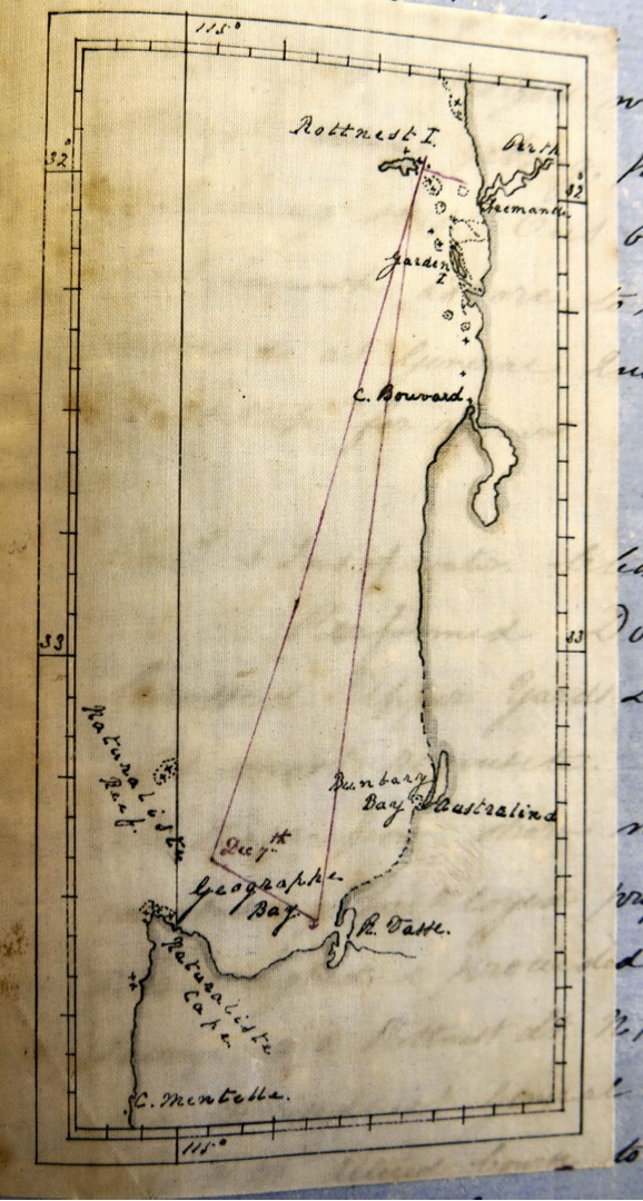
11 November 1871

1515. Left St Pauls Island.  Wind north force 2 becoming NE force 2 to 3. Barometer 30.40 inches. Maximum temperature 61F. Under steam. Up Top gallant masts and crossed upper yards.

1515 Weighed and proceeded under steam.

1700. Stopped. Made all plain sail save for Royals, Spanker and Flying jib.. Up screw. Unbent cables and stored anchors.

1930 Last sight of St Pauls Island WNW. Course ESE. Wind NE.

12 November 1871

Latitude 38.57S. Longitude 79.35E. Course S80E. Wind NE force 3. Under sail.

Performed Divine Service

13 November 1871

Latitude 39.22S. Longitude 82.33E. Course S80E. Wind NE force 3. Under sail. Fine weather and very smooth seas. All plain sail.

14 November 1871

Latitude 39.19S. Longitude 85.16E. Course N88E. Wind NE  force 2 to 3 becoming NNE force 2. Under sail. Barometer 30.34 inches. Settled weather. Plain sail and Topmast Stud sails.

15 November 1871

Latitude 39.9S. Longitude 87.24E. course N84E. Wind NNE force 3 becoming SE force 4. Under sail. Barometer 30.20 inches.

As for the 14th and Top gallant stud sails  until 1400 when we were taken aback with the wind from S by W with rain. Braced round. Barometer had been falling slowly since noon of the 14th and was now 30.13. double reefed Top sails and reefed Courses. In Mizzen topsail. Force of wind 4

16 November 1871

Latitude 38.31S. Longitude 90.8E. Course N70E. Wind southerly force 5 becoming SSE force 3. Under sail.

0100 Wind increased to force 6 to 7 . Barometer falling steadily. Close reefed Top sails.

0730. Out second reefs.

1700. Reefed Course. Barometer 29.90 inches. Swell from SW and after 2000 the wind fell light from SW.

17 November 1871

Latitude 37.46S. Longitude 91.31E. Course N59E. Wind WSW force 2 becoming SW force 4. Under sail. Barometer steady at 30.05 inches.

Daylight. Out reefs. Plain sail save for Mizzen royal and Topmast stud sails.

1700 In first reefs.


18 November 1871

Latitude 37.15S. Longitude 94.45E. Course N79E. Wind south westerly force 3 becoming WNW force 3.

Under sail. Fine clear weather. Plain sail and top gallant stud sails.

1400.Wind shifted to the northwards. Barometer falling from 30.04 inches at 0800.

19 November 1871

Latitude 36.57S. Longitude 98.5E. Course N83E.  Wind WSW force 4 becoming  W by N  force 3. Barometer 29.89 inches. Maximum temperature 56F. Under sail.

0100  wind shifted from the WNW to WSW.

Daybreak . One sail in sight. Performed Divine Service. Plain sail save mizzen Royal and Spanker.

1700 in second reef of Top sails. In Royals and mizzen top gallant sails. A great number of birds were seen today; chiefly the Swallow.

Midnight.  Wind WNW. Barometer 29.84 inches and falling. A SW swell.

20 November 1871

Latitude 36.50S. Longitude 101.43E. Course N88E. Wind north westerly force 4 becoming NNW force 5. Under sail. Barometer 29.77 inches. Wind shifting to the northward. The weather very threatening in appearance..

1700. Close reefed Fore and Main topsails. Reefed Courses.  Barometer falling.

2000. Barometer  29.61 and rising

21 November 1871

Latitude 36.23S. Longitude 104.44E. Course N79E. Wind  westerly force 2 to 4 becoming W by N force 4. Under sail. Barometer rising.  Course east.

0300. Weather improving. Out reefs and made sail to Top gallant sails.

Noon. Altered course to E ½ N. Strong westerly winds. Ship making good speed.

22 November 1871

Latitude 35.29S. Longitude 108.17E. Course N73E. Wind west force 5 becoming WNW force 5.

Under sail. Wind steady. Rottnest Island Light House N61E 41S.

Midnight. Barometer 29.93 inches.

23 November 1871

Latitude 34.21S. Longitude 112.4E. Course N70E. wind NW by W force 6 becoming W by S force 5.  Under sail. Strong westerly wind. Barometer falling. 0800. 29.84 inches; from then rose steadily.

24 November 1871

Latitude 32.30S. Longitude 114.54E. Course N52E. wind SW by W force 6 becoming south westerly force 5.  Under sail. Maximum temperature 62F.

0235. Lowered Top gallant sails to a squall from WSW to WNW. Strong SW wind. Squally weather and showery.

Noon Course NE by E.

1600. Observed land NE by E.

1630 light House Rottnest Island  ENE.

1800. Duck Rock S82E. pilot met us halfway but did not take him onboard .

1950. Came to in Gage Road in 5 ½ fathoms with sandy bottom and veered to 6 shackles. A…

Latitude 32.30S. Longitude 114.54E. Course N52E. wind SW by W force 6 becoming south westerly force 5.  Under sail. Maximum temperature 62F.

0235. Lowered Top gallant sails to a squall from WSW to WNW. Strong SW wind. Squally weather and showery.

Noon Course NE by E.

1600. Observed land NE by E.

1630 light House Rottnest Island  ENE.

1800. Duck Rock S82E. pilot met us halfway but did not take him onboard .

1950. Came to in Gage Road in 5 ½ fathoms with sandy bottom and veered to 6 shackles. Anchorage bearings. Arthurs Head  Light House S30E. Menstan (?) Rock S69W.


Remarks

We have made a tolerable quick passage having 40 days including 5 at anchor of St Pauls and if it had not been for us calling there we should most probably have done it in 30 days as the wind were stronger to the south in latitude 40 and 39. For in general in edging up  for St Pauls the wind fell lighter. On leaving the Cape we had easterly winds with overcast cloudy squally weather until the 5th day from port when we fell in with the westerly winds in latitude 41S. Longitude 25.41 E with a long heavy swell. On leaving St Pauls we has north easterly breezes for 3 or 4 days and stood south to latitude 39.20S. Longitude 87.24E where the wind came from SE and southward gradually hauling round to the westward by which we reached Fremantle, the wind shifting to the south westward within 100 nautical miles from the land where we met with a heavy swell. Then we experienced the whole breeze. Currents have very irregular with the exception of 3 days easterly set after leaving St Pauls of about 12 miles a day.

Hidden Gems

The Island of Kotka was attacked in 1855, but the garrison had already departed: barracks, stores and magazines etc were destroyed and the squadron left, leaving COSSACK in charge of the Island.

Anchor crest

Receive our newsletters?