This is the story of the second ship to bear the name HMS Cossack.

Originally ordered by Russia for the Black Sea Fleet in December 1852 at a cost of 290,000 silver roubles, the ship was sold to the Hamburg trading house of Henry Mersk & Co. when relations between Britain and Russia deteriorated, as Russia feared possible confiscation.

The original contract price for the vessel, then named Witjas (Cossack), was £46,198, including £16,750 for machinery. The Admiralty subsequently paid the contractors £9,591 to complete the contract (of which £4,187 was for machinery), plus £751 for tonnage exceeding the specification and £2,206 for modifications for His Majesty’s service. The ship remained in service until 1875.

Year by Year

Discover the history of the HMS Cossack from 1854 to 1875.

You can search the ‘year’ and ‘month’ to find a specific date and also ‘click’ on the date itself to reveal any images and moments from that date.
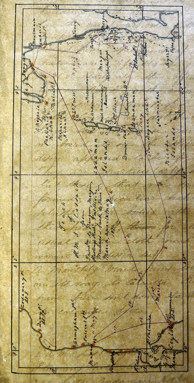
15 April 1871

Wind westerly force 2 becoming south westerly force 2.

Employed cleaning ship. Steamer  AVAGEE arrived.

16 April 1871

Calm becoming NW force 1.

Performed Divine Service. Sent Roman Catholics to Chapel. Gave leave to both watches.

17 April 1871

Wind NW force 1 becoming SE force 2. Unmoored ship and weighed port anchor.

1400. Weighed and proceeded down river river in charge of a pilot. On passing Clifford Rocks we had 5 fathoms  ( Nearly high water) and least water 4 ½ fathoms.

1620 Came to off Anchoring Creek in 6 ½ fathoms with broken bottom and veered to 2 ½ shackles.

18 April 1871

Wind east force 1 becoming SW by S force 2.

0800  British mail steamer NEMESIS arrived from Maulain with Commissioners of Tanasserim on board.

1000. English steamer DEFIANCE from Taroy and Mergui arrived.

1255. Weighed and proceeded down river in company of NEMESIS.

1545. Discharged pilot. Shaped course SSW.

1600 Double island Light House SSE ½ E.

1740.   Double island Light bore E by N. 8 nautical miles.

2000.NEMESIS E by S.


On leaving the mouth of the river the sea was breaking over…

Wind east force 1 becoming SW by S force 2.

0800  British mail steamer NEMESIS arrived from Maulain with Commissioners of Tanasserim on board.

1000. English steamer DEFIANCE from Taroy and Mergui arrived.

1255. Weighed and proceeded down river in company of NEMESIS.

1545. Discharged pilot. Shaped course SSW.

1600 Double island Light House SSE ½ E.

1740.   Double island Light bore E by N. 8 nautical miles.

2000.NEMESIS E by S.


On leaving the mouth of the river the sea was breaking over the reef which is marked by a single buoy without a staff or ball.

19 April 1871

Latitude 13.55 N. Longitude 97.16. Course S3W. Wind SSW force 2 becoming west force 2. Barometer 29.98 inches. Under steam and sail.

0100. Set fore and aft sail. Daylight observed land SE by E and NEMESIS on starboard bow..

1210 Altered course to SE by S. made sails to Top gallant sails.

1600 Course SE. Stopped.

2010. Furled sails and proceed under steam.

2235. Departed this life Thos. Gould AB. Lighting to the Eastward and westerly wind force 2 to 3.

20 April 1871

Wind variable with light airs from the south. Under steam.

0200 Observed land on port bow E by S.

0245. Altered course to SE by S.

0310. Altered course to SSW.

0330 Taroy Point  E by N ½ N.  Cabotta SW 1/2/ W.

0345. Stopped and sounded in 21 fathoms.. Daylight. Little Canister E ½ S. Tanasserim SSW ½ W.

0510 Proceeded.

0800. NEMESIS sighted steaming up inside of Taroy Point Island.. altered course ESE. Passed through channel between Iron Island and Little Camister and Tory Rocks. Here we me…

Wind variable with light airs from the south. Under steam.

0200 Observed land on port bow E by S.

0245. Altered course to SE by S.

0310. Altered course to SSW.

0330 Taroy Point  E by N ½ N.  Cabotta SW 1/2/ W.

0345. Stopped and sounded in 21 fathoms.. Daylight. Little Canister E ½ S. Tanasserim SSW ½ W.

0510 Proceeded.

0800. NEMESIS sighted steaming up inside of Taroy Point Island.. altered course ESE. Passed through channel between Iron Island and Little Camister and Tory Rocks. Here we met with strong tide eddies, being high water at Mergui.

Noon. The beacon marking the entrance to the river were very different to make out. They were rather small and consisted of a black and white basket on a pole. The third beacon marking the shoal on the western side of the river is a t present not there. The  forth is a buoy ( white and a staff) about a mile north from pier.

1245 Came to in Port Mergui with sandy bottom in 3 ½ fathoms and veered to 1 ¾ shackles..

1630. Sent a Funeral party on shore to inter the remains of Thos Gould. AB who died of heart disease  on the night of the 20 April.


Remarks

The town of Mergui is very small and few Europeans live on the side of the hill above the native town and is tolerably large with a large white Bazaar which is seen a great distance off. There appears to be no particular trade to this place as only dhows were in the harbour. The DRYAD when she about two months ago anchored off the Kings island and communicated with boats.

21 April 1871

Left Mergui for Hastings Harbour. Wind variable force 1 becoming west force 2.

1035 Weighed and proceeded out of harbour. Captain Pearce and Colonel Brown embarked onboard NEMESIS. Steamed out between beacons and Kings Island and Iron island. Found here very strong tides in eddies. NEMESSIS steamed southward inside islands.

1600 Little Canister N15E. North point of Iron island N by E.

1635. Course SW ¾ S.

1800. Western Canister N69W. Mount Elphinstone (?) S by E.

2000. Mount Elphinstone S by E.…

Left Mergui for Hastings Harbour. Wind variable force 1 becoming west force 2.

1035 Weighed and proceeded out of harbour. Captain Pearce and Colonel Brown embarked onboard NEMESIS. Steamed out between beacons and Kings Island and Iron island. Found here very strong tides in eddies. NEMESSIS steamed southward inside islands.

1600 Little Canister N15E. North point of Iron island N by E.

1635. Course SW ¾ S.

1800. Western Canister N69W. Mount Elphinstone (?) S by E.

2000. Mount Elphinstone S by E. Tanasserim Island NW.

2200. Mount Elphinstone E by N1/4 N. Smart Island SE. Course S ¼ E.

2230. Set Fore and aft sails.

22 April 1871

Latitude 10.58N. Longitude 97.57E.  Wind SE force 2 becoming southerly force 1. Barometer 29.85 inches. Maximum temperature 87F.

0400. Fletcher island NW by W.

0430 Altered course to S ¼ E. 0800. Black Rock NW by W ½ W. Steering for Lord Loughborough Island.

1740 Came to of Lord Loughborough Island in 14 fathoms with sandy bottom. Veered to 65 fathoms. Anchorage South Sentinel N15W and centre Sir W James island E 12 N. Sent cutter and gig away armed to examine village which was found deserted…

Latitude 10.58N. Longitude 97.57E.  Wind SE force 2 becoming southerly force 1. Barometer 29.85 inches. Maximum temperature 87F.

0400. Fletcher island NW by W.

0430 Altered course to S ¼ E. 0800. Black Rock NW by W ½ W. Steering for Lord Loughborough Island.

1740 Came to of Lord Loughborough Island in 14 fathoms with sandy bottom. Veered to 65 fathoms. Anchorage South Sentinel N15W and centre Sir W James island E 12 N. Sent cutter and gig away armed to examine village which was found deserted with only the sticks or poles that form their hut left. We have come here (Archipelago0 for the purpose of taking the pirates that frequent these islands during the fine monsoons. Their business appears to be to stop trading vessels (dhows chiefly) and demand the most valuable things but if resistance is shown they will use force and the consequence is people have been killed. These pirates are from Singapore. Four or five men are at present under sentence of death. Most of the islands we passed between were thickly wooded down to the water sedge.  The natives in the fine weather inhabit the outer islands and go in when the SW monsoon commences.. The Black Rock shows a very perpendicular face to the northward and not a vestige of shrub or anything but rock.  Once or twice small rocks were mistaken for sail. We gave chase until we saw our error.

23 April 1871

Latitude 10.15N. Longitude 98.25E. wind SE force 1 to 2 becoming SW force 2.

0100. Very heavy rain with thunder and lightning.

0540. Weighed and proceeded.

0800.  Quion Island S 77W SE Hump S 70E..

0845 Course SE by S for Russell’s Island. . Performed Divine Service. Observed a junk ENE and proceeded after her at full speed.

1142 Stopped and boarded the junk. She had bill of clearance.

1155 Proceeded NW.

1530 Stopped and came to in Hastings Harbour with Sand bottom in 7 fathoms and veered to …

Latitude 10.15N. Longitude 98.25E. wind SE force 1 to 2 becoming SW force 2.

0100. Very heavy rain with thunder and lightning.

0540. Weighed and proceeded.

0800.  Quion Island S 77W SE Hump S 70E..

0845 Course SE by S for Russell’s Island. . Performed Divine Service. Observed a junk ENE and proceeded after her at full speed.

1142 Stopped and boarded the junk. She had bill of clearance.

1155 Proceeded NW.

1530 Stopped and came to in Hastings Harbour with Sand bottom in 7 fathoms and veered to 20 fathoms.  Anchorage. South point of Hastings Island E by N. Haycock island N12 W.

24 April 1871

At single anchor. Wind calm becoming westerly force 1 to 2. Loosed sails to dry.

1520 Sighted NEMESIS.

1615 NEMESIS anchored.

25 April 1871

Wind calm becoming SW force 1.

0530. NEMESIS sailed with Captain parish and Colonel Brown for Pak-chan River. During night lightning to the eastward. Loosed sails to dry.

1750 Out boats which were manned and armed. Boats away firing shot and shell at rock on shore.

26 April 1871

Light airs becoming west force 1.

Employed s requisite. Exercised pivot guns firing shot and shell at object on shore.

2100 Thunder and lightning  and cloudy to eastward.

27 April 1871

Wind calm becoming North force 1.

1800 Hoisted in second cutter for repair. Marines at company drill. During our stay here it has been intensely  hot. The harbour being entirely closed that we seldom had any breeze. A slight breeze from the northward set in about noon for two to three hours. The islands abound with monkeys;  and they say wild hogs but we did not see any of them. The NEMESIS  on going up the Pak-chan river passed across a mud flat and to the northward of the islands at entranc…

Wind calm becoming North force 1.

1800 Hoisted in second cutter for repair. Marines at company drill. During our stay here it has been intensely  hot. The harbour being entirely closed that we seldom had any breeze. A slight breeze from the northward set in about noon for two to three hours. The islands abound with monkeys;  and they say wild hogs but we did not see any of them. The NEMESIS  on going up the Pak-chan river passed across a mud flat and to the northward of the islands at entrance. She went right up to the town. Several junks passed the eastern entrance whilst here but where only traders.
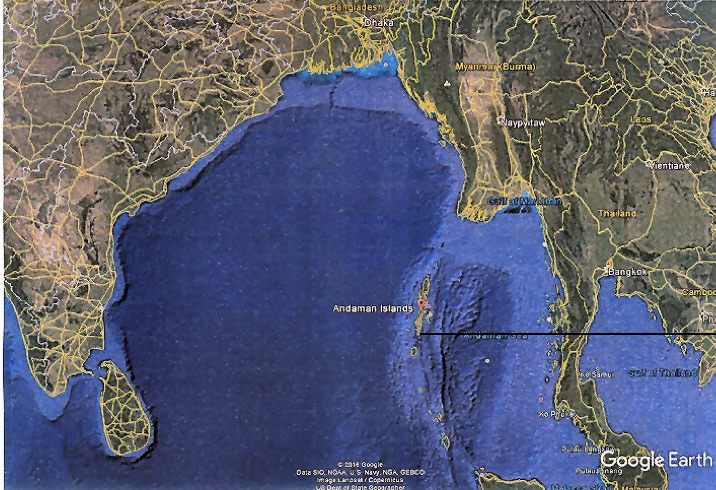
28 April 1871

1400. Left Hastings Harbour for Port Blair (Andaman Island). Wind calm becoming NW force 2. Loosed sails. Exercised at General Quarters. Lifted screw for examination. In boom boats.

1000. NEMESIS arrived.

Noon. NEMESIS sailed.

1315 Weighed and proceeded out of harbour. Wind NW.

1400 Shaped course W by N ½ N.

1600.  Russel’s Island East. NW Hump north 20 E.

1845 Set Fore and aft sails. Wind north westerly force 3 to 4 with broken cloud.

29 April 1871

Latitude 10.34N. Longitude 96.26E. Course N80W. Wind NW force 2  becoming N by W force 2.

Under steam. Daylight – two sails in sight.

1000Passed through a strong tide rip. .

1600. Wind northerly force 2 with broken cloud.

30 April 1871

Latitude11.16N. Longitude 94.20E. Wind NW by 2 becoming light airs. Barometer 29.90 inches. Maximum temperature 88F. Port Blair N75W 97 nautical miles.

Under steam and Fore and aft sails. Performed Divine Service. Swell from  south westward

1800. Altered course to W by N.


Sailing from Hastings Harbour to Port Blair and Madras.

01 May 1871

Single anchor off Ross Island, Port Blair. Wind north westerly force 2 becoming northerly force 2.

0200. weather cloudy and misty. Could not make out land although dead reckoning placed us within sight of land.

0425. Stopped.

0500 Proceeded. Land ahead on starboard bow.

0600. Ross island N ½ W.

0740. Altered course  to WNW.

1030. Arrived in Port Blair. Stopped and came to with sandy bottom in 9 fathoms and veered to 3 shackles.  Anchorage bearing Atalanta Point N70W.. South Point S7E. We were…

Single anchor off Ross Island, Port Blair. Wind north westerly force 2 becoming northerly force 2.

0200. weather cloudy and misty. Could not make out land although dead reckoning placed us within sight of land.

0425. Stopped.

0500 Proceeded. Land ahead on starboard bow.

0600. Ross island N ½ W.

0740. Altered course  to WNW.

1030. Arrived in Port Blair. Stopped and came to with sandy bottom in 9 fathoms and veered to 3 shackles.  Anchorage bearing Atalanta Point N70W.. South Point S7E. We were to have secured to the pier at Chatham Island for the purpose of coaling but the Master attendant thought as they had not such a large vessel up there before it was not advisable to go up  in our case. Therefore we coaled from a lighter manned by the convicts the next day and by 1500 received 114 tons.

02 May 1871

Wind WNW 1 becoming north easterly 2. Barometer 29.97 inches and falling. Coaling received 114 tons

03 May 1871

Wind West force 2 becoming SW force 3 during the forenoon.

17.30. Left harbour under steam.

1800. South Point Ross Island NW.  Set fore and aft sails.

Remarks

Ross Island appears very conspicuous by the tree standing in the centre of the buildings which are seen a good distance off. In the neighbourhood the forest has been completely cleared with exception of here and there specimens of very fine tall palms are left standing.

Most or nearly all the officers of the settlement live on Ross islan…

Wind West force 2 becoming SW force 3 during the forenoon.

17.30. Left harbour under steam.

1800. South Point Ross Island NW.  Set fore and aft sails.

Remarks

Ross Island appears very conspicuous by the tree standing in the centre of the buildings which are seen a good distance off. In the neighbourhood the forest has been completely cleared with exception of here and there specimens of very fine tall palms are left standing.

Most or nearly all the officers of the settlement live on Ross island with two Companies of a  European Regiment and some native regiment. The greater portion of the convicts are distributed about.

Some Andamese men and women came on board to see the ship but there chief desire appeared to be for tobacco and biscuits. They are particularly small people but those that we saw were well formed. A particular habit of theirs is to plaster their bodies with clay which kept the heat off. The men wear the usual native cloth round the middle and the women even less (a leaf).

A monthly mail runs between tis and Rangoon on its way to Calcutta. A party of convicts have been sent down to colonise Island Nicobar.

04 May 1871

Latitude 10.20N. Longitude 92.29E. Wind SW by S force 2 becoming SW by W force 4. Barometer 29.81 inches. Maximum temperature 84F.

Under steam and sail.

0200. Lost sight of land NW by N. Steaming south to round Little Andaman.

0745 Little Andaman NW by W.

0800 Course WSW.

Noon Little Andaman N ½ W. Wind SW by W force 4.

Hidden Gems

The Island of Kotka was attacked in 1855, but the garrison had already departed: barracks, stores and magazines etc were destroyed and the squadron left, leaving COSSACK in charge of the Island.

Anchor crest

Receive our newsletters?