Year by Year
Discover the history of the HMS Cossack from 1854 to 1875.
You can search the ‘year’ and ‘month’ to find a specific date and also ‘click’ on the date itself to reveal any images and moments from that date.
07 March 1871
becoming NW force 1. Barometer 30.10 inches.
Under steam and sail. Rangoon Light N27E 88 nautical miles. Daybreak observed discoloured water.
0900. Altered course to NE by E. Wind northerly force 2 with broken cloud.
1245. Altered course to NE by N.
1540. Stopped and sounded in 11 fathoms (mud).
1545.Altered course NNE.
1640. Course n by E ½ E. shortened and furled sails. Wind fill light from southwards. Soundings varying from 8 ½ to 9 ½ fathoms.
1010. Course N by E. Passed several vessels. 1130. Course NNE.
1150. Observed China Bucher Light Pier at 15 miles bearing NW. Altered course to N by W.
08 March 1871
8 March 1871. Steaming up the River Rangoon in charge of pilot. Wind calm becoming SSE force 2.
0040. Observed Eastern Grove bearing NNE.
0052. Stopped.
0055. Came to with sandy bottom in 6 fathoms and veered to two shackles.
0545. Fired a gun and hoisted Pilot jack.
0930. Pilot came onboard but owing to the ebb tide we did not weigh until about 1145 in order to use the flood tide. Several vessels were at anchor. Proceeded up the river and moored off the main wharf in 7 fathoms on a mooring swivel at 1715. Moored the ship with 3 shackles on each cable. Found here Italian corvette PRINCESS CLOTILDA. Anchorage bearings China Bucher Light W ½ N. Eastern Grove Light N by E ½ E. Church steeple N43W. Flag staff N4E.
Remarks.
Moored off Main Wharf – Rangoon March 1871
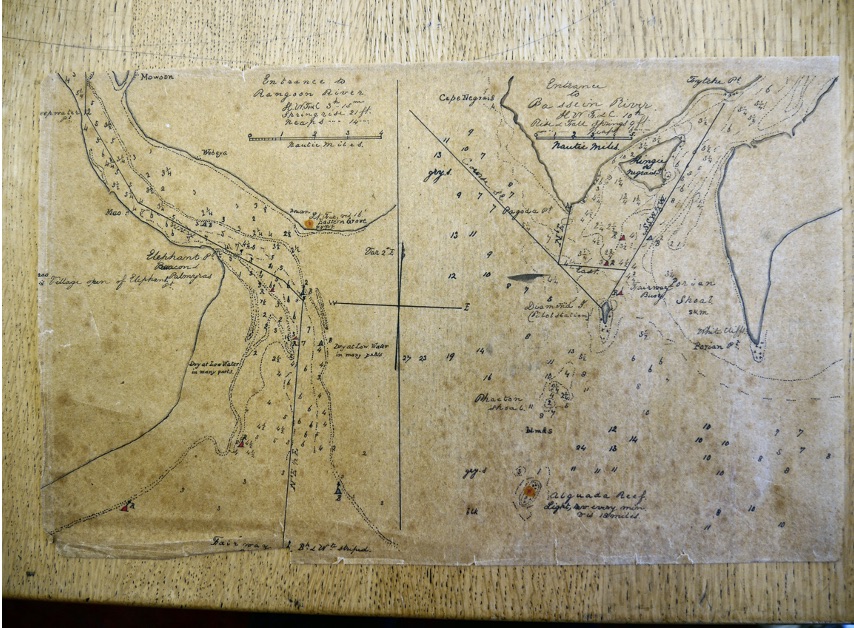
During our passage across we steamed the whole time with sail set when the wind would stand except for a space of 10 hours when we proceeded under fore and aft sails whilst the key connecting the slide valve rod with the slides was being replaced by engineers. We passed no sea weed and saw very few birds. Several vessels were sighted standing to the southward and westward. Of the morning of the 6th sighted Landfall Island and the Andamans a little later. The latter appeared very high; the former low and covered with trees. The Coco’s showed out like a lot of trees as they are low islands and well wooded. Table Island is well deserving of its name as it is very flat and not many trees. The light house is an iron tower with red and white bands. The light is a flashing 2 – visible 22 miles. Vessels should not approach within one mile as there are some rocks off the north side. They have a flag staff on which they hoisted the diamond. Daybreak of the 7th we were in the discoloured water which of course got gradually worse as drew near off the mouth of the river. The tide ran very strong. We swung head to NE with the ebb which bought down very muddy waters. The mouth of the river is buoyed with buoys that are black on the starboard hand and white on the port hand. The number of buoys each side are about four. The outer black one being striped white and known as the Fairway Buoy. It also has a staff and plate. There is a large stone pillar; the upper part red and the lower part white on Elephant Point with some tall palmyras trees which mask and would not be seen very far but shows the mouth of the river on the opposite side ( Eastern Grove) a light house that has been lately raised, but this light although of good power is not at a height it ought to be as vessels making for China Buchur Light on a NNW course have no guide to tell them when they are close to it or not as the Eastern Grove light is not then in sight and therefore no bearings. A vessel ran ashore on the spit off China Buchur on the 5 April 1871 through not knowing the distance off. On entering the river a NNE course takes you up until Mao village just opens up off Elephant Point Light House bearing NE alter course for the village about WNW. Keep the west shore ( A black buoy marking the shore on the starboard hand) until just above Deep Water Point where you sheer over to East shore keeping Syrian Pagoda open a little to the right of a single tree that will be seen nearly on with it close to the shore. From here you keep East shore until you open the shipping well off Rangoon and then sheer across Hastings Shoal. This shoal is the most dangerous as at low water there is only about 1 ¼ fathoms on it and therefore vessels have to wait sometime before crossing it.. A mark for telling the height of the water here is on a pier on Monkey Point where if the horizontal beam is seen there is less than 18 feet on the shoal. If the beam is covered there is over 18 feet of water on the shoal. This shoal is formed by the meeting of the two rivers but does not increase in the slightest according to the Pilots.
The tides run very strong and boats will easily capsize by getting athwart of any vessel.
