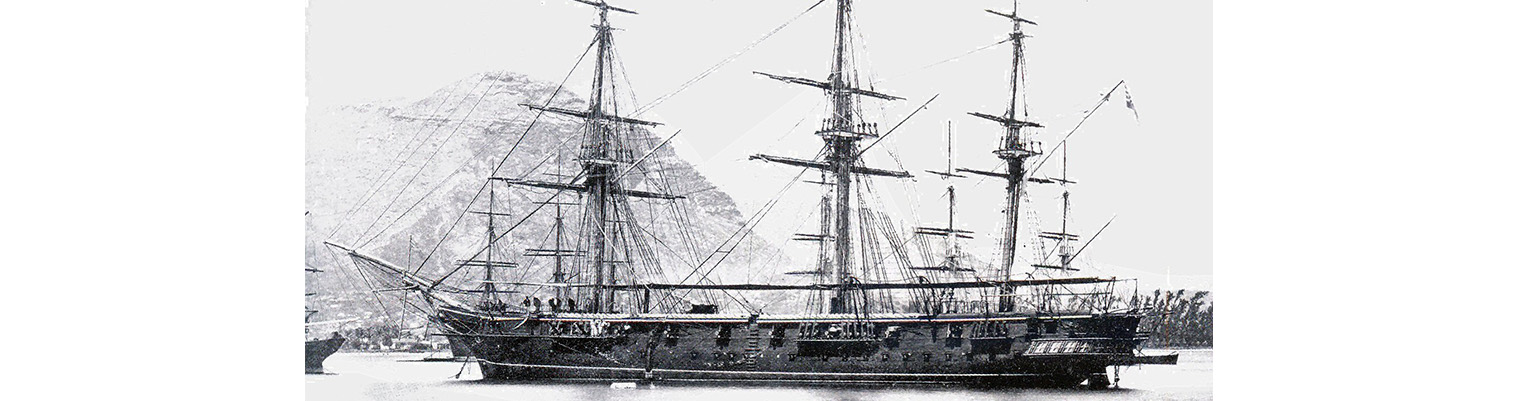
Year by Year
Discover the history of the HMS Cossack from 1854 to 1875.
You can search the ‘year’ and ‘month’ to find a specific date and also ‘click’ on the date itself to reveal any images and moments from that date.
07 March 1870
Latitude 7.8S. Longitude 47.7E. Wind NNE becoming SE and then ENE force 2 to 3 dying to 1. Course ESE / SE / NNW / N by E.
0115 In Top gallant sails.
0600. Wore. Set op gallant sails. Read prayers and mustered at Quarters. Carpenters altering netting. Artificers making good small defects. Watch employed pointing breechings.
1125 Wore. Set Royals, Flying jib, Topsails, Top gallant stud sails.
PM as per AM plus refitting gun tackle.
1400. In Top sails and Top gallant stud sails. Up Mainsail, squared yards.
1545 Braced forward on Starboard tack. Set mainsail. Washed clothes
2045. Longitude by Regulus 46.56S
( also known as Alpha Leonis is the brightest star in the constellation of Leo)
08 March 1870
Latitude 5.28S. Longitude 47.13E. Wind Easterly becoming South-easterly force 1 to 2. Course North – easterly.
0500 Lit fires under port boiler for condensing.
0545. Trimmed.
0810 Shifted Mainsail. Mustered Quarters and prayed.. 3rd class of drills at cutlass drill. Pointing breechings and making mats.
PM. First company of small arms men at rifle drill. Midshipmen and boys at gun drill. Employed refitting gun gear. Sailmakers repairing mainsail.
1645. Mustered at Quarters. Shifted top gallant masts. Latitude of Regulus 6.15S.
11 March 1870
Latitude 4.50S. Longitude 48.55E. Wind northerly force 2 increasing to 3. Course E by N.
0605. Rounded in.
0900 Mustered at Quarters. Prayed. 3rd class at cutlass drill. Marines at gun drill. Sailmakers making good small defects.
0930 Set Royals, Port topmast and Top gallant stud sails..
1330 altered course to East. Midshipmen and boys at gun drill. Second company of small arms men at rifle drill. Training party at gun drill. Pointing breechings. Mustered at Quarters. Shifted Mainsail.
2351 In Stud sails. Braced forward.
13 March 1870
Latitude 4.48S. Longitude 53.6E. Silhouette Island N.81E 133 miles. Wind north easterly force 1. Course Easterly becoming northerly..
0715 In fore and aft sails and Foresail.
0800. Course East.
0930. Observed land SE to NE.( African Isle).
1000 Course North. Mustered by Divisions. Divine Service.
1110. sounded in 80 fathoms.
1250 Course NE by E.1320 Set Head sails and Trysail. 1430. Course E by E.
1650 Muster by Divisions.2015. Done Head sails and in Trysail.
2145. Sounded in 12 fathoms on edge of bank.
2230. Sounded in 25 fathoms(sand and coral) and 21 fathoms
14 March 1870
Latitude 4.32S. Longitude 55.27E. Wind at 0100 NE force 1 becoming calm until 1600 when it came from the west at force 1 until 2000 when it became calm again. Course Easterly.
0200 Altered course to east.
0345 Sounded in 35 fathoms (sand).
0415. Observed land bearing east to ESE.
0435. Altered course to E by S.
0800. Squared yards. Mustered at Quarters.
0930 North Isle and Silhouette Island in one bearing N by E1/4 E. Praslin Island ENE. Training party at gun drill. Watch fitting gun gear.
1310. Received pilot on board..
1400 Came to with broken bottom in 11 fathoms.. Moored ship with 4 shackles on broken bottom and three on sandy bottom. Out small boats. Unrove messenger. Employed scrubbing hammocks and washing clothes. Anchorage bearings – English church W1/2 N; North Maki N ½ E
(Praslin Island – the second largest island of the Seychelles, lying 44 km northeast of Mahé. Praslin has a population of around 7,533 people and comprises two administrative districts: Baie Sainte Anne and Grand’ Anse.
