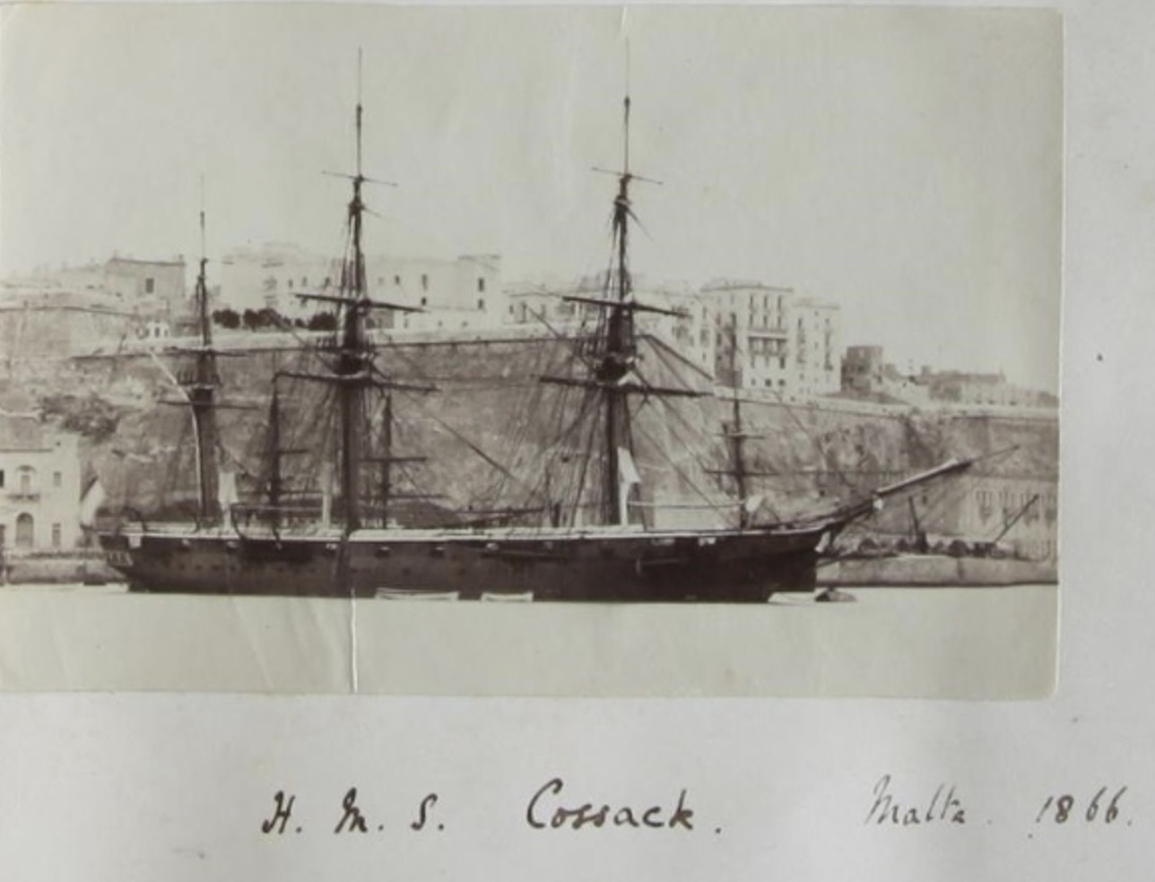
Year by Year
Discover the history of the HMS Cossack from 1854 to 1875.
You can search the ‘year’ and ‘month’ to find a specific date and also ‘click’ on the date itself to reveal any images and moments from that date.
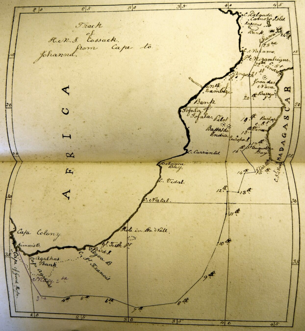
07 May 1869
Latitude 39.22S Longitude 30.41E. Cape Natal bearing N2E 568 miles. Course South Easterly changing to Easterly. Wind Northerly Force 6 to 9. Barometer 29.41 inches dropping to 29.10 inches over 15 hours then rising to 29.40 inches at Mid night. Temperature 71F dropping to 68F. Maximum sped through the water 7 knots.
0010. In second reef of fore and main topsails. Down Jib. In third reef of Mizzen topsail. Down royal yards. In third reef of Fore top sail. Furled Mizzen topsail. Down Top gallant yards.
0415 Reefed Mainsail; on preventer, braced.
0545 Up Courses. In third reef of Main top sail. In fourth reef of Fore topsail. Set Fore staysail. Down Flying Jib staysail.
0715 Wind shifted suddenly to NW. Squared yards and furled Courses.
1315. Braced forward on Port tack.
1350. Course ESE.
1400 Heavy squall from North accompanied by rain.
1515 Course East.
1630 Down Top gallant masts. Close reefed main top sails.
2015 Course E by S.
08 May 1869
Latitude 38.30 S Longitude 34.43E. Course Easterly. Wind NW to W Force 7 to 9 reducing to 8 about 1600. Barometer rising from 29.43 to 29.78 over the 24 hours. Cape of St Mary Madagascar N55E 936 miles.
AM Lightning from the SW.
0800 course East.
0810 Sea struck Port waist damaging the nettings.
0900 Set Foresail.
1020 Out fourth reef of the Fore and Main topsails Set Fore top stay sails.
1310 Fore staysail halliard carried away. Down Fore Staysail and spliced halliard.
1335 A heavy squall of rain and hail from the NW shifting to West. Stars obscured
10 May 1869
Latitude 33.23S longitude 38.57E. Course NE. Wind Westerly Force 4 to 6 AM 4/5 PM.
0200 Out third reef of Fore Topsail and reef of Mainsail. Set windward clew of the Mainsail.
0600. Up Mainsail and out second reef. Set single reefed Mizzen topsail. Quarters and prayers. Crossed Top gallant yards. Braced up on Port tack. Set Top gallant sails and the clew of Mainsail and Jib. Up stud sails and losing sails to dry.
PM Watch pointing and grafting.
1300 Course NE by ½ N. Carpenters making lockers on lower deck. Boys at Seamanship. Shifted Fore and Mizzen topsails.
13 May 1869
Latitude 29.08S. Longitude 40.58E. Course Easterly until 1500 then NE by N. Wind North Easterly until 2340 then SW. force 5 reducing to 2 and then increasing to 4 during the morning. 4 to 6 pm reducing to force 2 at Midnight.
0550. Up courses.
0730 Set Courses and second reef to Topsails, Fore Jib staysail and Top gallant sails.
0900 Mustered at Quarters Set Spanker. Crew fitting sails while Marines at rifle drill. Carpenters making gratings.
PM Make and mend clothing.
1500 course NE by N. In Spanker.
1645. Mustered at Quarters.
2220. Up Mainsail.
2243. Squared yards.
14 May 1869
Latitude 27.24S longitude 41.52 E. Course Northerly until 1300 then South until 1400 then NNE to 1600 then Easterly. Wind NNE force 2/3 increasing to 5 from the South before decreasing to 2 from the SSE becoming force 1 from the East at Midday. It then increased to 4 from the NW before decreasing to 1 at Midnight. Broken cloud becoming overcast. Barometer 30.12 dropping to 30.10 inches before rising to 30.15 inches. Temperature 69 to 78F.
0030 Braced round on Starboard tack.
0200 Tacked and set mainsail.
0345 lowered Topsails to a squall with heavy rain. Set Topsails.
0500 Squared yards. 0900 Quarters and prayers. Small arms men at rifle drill.
1030. Braced sharp up. (To cause the yards to have the smallest possible angle with the keel for the ship to have headway – usually 20o with the keel)
1145. Shortened sail to Topsails. In Jib and Flying jib staysail.
PM cutlass men of watch at drill.
1315. Ware ship. Set courses, Top gallant sails and Royals.
16.45 Mustered at Quarters. In first reef of Topsails.
1810 Set Courses.
2345 latitude by Spica 26.37S.
19 May 1869
Latitude 21.02S Longitude 42.09E. Course N by E ½ E. Wind SSW. Force 5 to 6 reducing 4/5 AM 4 / 3 increasing to 5 PM.
0040 In Top gallant sails. In first and second reefs of mizzen topsail.
0730 Set Main Top gallant sails.
0800 set Starboard Topsail stud sail followed by prayers. Exercised at General and Fire Quarters. Mainsail being repaired and boys at seamanship.
PM course N by E ¼ E.. Mainsail still being repaired.
1650 Quarters. 1845 Trimmed.
2000 course N by E
- In Fore Top gallant Stud sail.
21 May 1869
Latitude 16.56S Longitude 41.53E. Course N by E ½ E. Wind SE Force 2. Johanna Isle bearing N29E 322 miles.
0740 Braced round on Starboard tack. Up weather clew of mainsail. Set lee clew of mainsail and Starboard Stud sail.
1140 Trimmed and set lower Stud sails.
1230 course NE by N. Training party at drill. Boys of watch at seamanship.
1650 Mustered at Quarters. In lower Stud sails. Trimmed Singled tacks and sheets. Latitude by Centauri 16.26S. (Centauri is the name given to what appears as a single star to the naked eye and the brightest star in the southern constellation of Centaurus.).
2340 Shortened sail to Topsails, Top gallant sails, Jib and Foretop staysail.
22 May 1869
Latitude 15.43S. Longitude 42.26E. Course North Easterly. Wind SE / ESE / SE. Force 1 increaseing to 4 at Midday and then decreasing to 2.
0100. Set Royals, Courses and Jib.
0230 Latitude by Mer alt Vega 16.12S.
1750 In Royals and Fore Jib.
0800 Course NE. Cleaned ship throughout.
1000 Observed waterspout on Starboard Quarter.
1050 Trimmed.
1400 Set Royals and Fore Jib. Cleaned ship.
1650 Quarters In first reef of Topsails 1900 course NE ½ E. Latitude by Crucis 15.25 S.
(Alpha Crucis is the brightest star in constellation Crux.)
23 May 1869
Off Johanna Isle. Course NE ½ E. Wind 2 increasing to 5 by midday then decreasing to 0. Wind SSE.
0015 Out reefs and set fore stud sails. Daylight observed Johanna Isle Madagascar off Port bow. Trimmed. In Top stud sail. Training party at cutlass drill. Men of watch at drill. Set Royals and Fore Jib. Squared yards and set both Top sails and main Top gallant sail.
PM shortened sails.
1300. Commenced steaming.
1600 Steaming.
1725 Came to off Johanna Isle. With (BB) in 10 fathoms. Veered to 36 Fathoms. Beacon SE by E Black rock E ½ N East extremity NE ¼ N. (BB is believed to stand for Bad Berth – foul or rocky anchorage.)